Friday, March 27, 2020

Mapping Vault Properties to Inventor iProperties

When I started this series about Vault Properties, I pointed out how there is a difference between Vault Properties and Inventor iProperties and I mentioned that it is possible to create a mapping between them.  In my last post, I explained how to create a Vault Property because I felt that most users will have to create that property first.  Primarily because most iProperties are already mapped to Vault.

So now that we understand that there is a difference and we have the necessary Vault Property, I want to explain how to create the mapping between our Vault Property and an Inventor iProperty.  The only other prerequisite is that we have to have an Inventor file that has the desired iProperty, in most cases, this will be a Custom iProperty.

The example I use to demonstrate this is a property called Stock Location.  It is the location in the warehouse that this part is stored.  My Inventor file will have a custom iProperty named Stock Location and it will hold that value.


As long as you have one Inventor file with that iProperty definition, you are ready to map it to your Vault Property.  Go to Vault and open the Property Definition dialog, select the property you want to map to, and click Edit. 


Then on the Mapping tab of the edit dialog, you will be able to click on "Click here to add a new mapping."  This will enable a row for you to define the mapping, each of these fields is a drop-down menu.  I always start with the Provider column.  Clicking in that cell will show a drop-down of all the different types of providers available.  In our case, we will pick Inventor (.ipt, *.iam, *.idw, *.ipn, *.ide).  Please note the other possible selections as well.


Then you will need to designate the File Property.  In this case, Vault will want a sample file that it will pull property definitions from.  It is capable of pulling from the Vault or from a local file, so make sure to pick the proper option based on where the sample file is stored.  Then click "Import Properties" and pick the proper option.
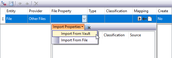

Then the user will be prompted to select the sample file and the File Property drop-down will be populated with all the properties defined in that file.


Then the user can select the desired property from the list.  I do want to point out that Vault will retain that same list during this session of Vault, so if you want to map several properties to properties from the same sample file, you will only need to pick that sample file once.  Also, if you pick a second sample file, this list will display both sets of properties.  If this list gets too cumbersome because of adding several sample files, the icon next to "Import Properties" will clear the list.

There are two other options here that are good to understand.  The Mapping will define if this is a bi-directional mapping or a one direction mapping.  For a user-defined property, you will have several options.  If you are mapping a Vault System Property to an iProperty, you will only be able to have Vault push its value to Inventor.  This is because Vault System Properties are not editable by users.  The "Create" option will tell Vault if it should create the property on the CAD file if it doesn't exist.  Once all of the options have been selected and the user clicks out of that row, the mapping is defined and moved below the line in the Window.

It is possible to create multiple mappings on the same properties, if multiple mappings exist, it is possible to order, or prioritize them from greatest to least.  


I will caution against creating too many mappings, I have talked to several customers recently that have cyclical, or conflicting, mappings and it resulted in undesired property behavior.  So be careful when creating multiple mappings for the same property.

Also, just creating the mappings will not automatically cause the property to be populated with the data from the CAD file.  Running a re-index on the Vault will prompt Vault to begin pulling the data from the mapped properties into the Vault database.  If you don't perform a re-index, the mapping will be carried out as files are checked into the Vault. 


Here is a YouTube video that shows the process.


That is all there is to it.  Following these steps, you should be ready to start mapping all of your custom Inventor Properties to Vault Properties.

Thursday, March 26, 2020

Creating a Vault Property

Since Autodesk Vault is run on a SQL database, it is a very powerful tool for keeping track of CAD files and their associated data.  The ability to search on the properties of Vault is one of the best ways to find and reuse designs.  Even though Vault is loaded with a variety of existing properties, it may become necessary to create your own Vault Properties.  So I wanted to dedicate one blog post, in this series about Vault Properties, to how to create a Vault Property.  Before I get into the steps in the process, I want to remind you that only users with an Administrator role will be able to do this.

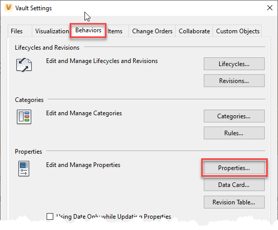
The first step is to open the Property Definitions dialog, which is located on the Behaviors tab of the Vault Settings dialog, which can be found by going to Tools> Administration> Vault Settings.


Property Definitions Dialog
Once you are to the Property Definitions Dialog, it is just a matter of click on New and entering the desired information.


For the most part, some of these options are straight forward.  For example, Name is the name of the property.  As long as you are not using special characters or duplicating an existing property name, there shouldn't be any issues here.  Type is just what type of data is going into this field.  Is it text, a number, a date, or a true/false value?

The Associations are a little more in-depth.  When it comes to Vault Basic, Vault Workgroup, or Vault Professional, there are different functions inside of Vault and the new property can be associated with any one of those objects.  The Associations get into is this going to be a property for files, if so, which categories?  Is the property going to be associated with Items, if so, what kinds?  And so on.


After Associations, the user will need to define some of the specific settings for that property.  One option is to have this property included when someone does a basic search.  There are also additional options to set an initial value, force a list of values, require a value, etc.  Each association can have these set independently from one another.

There is a tab for Mapping.  This will allow users to create a mapping between the Vault Property and properties of the actual CAD files, such as Inventor's iProperties.  Property Mapping should really be a post of its own.  So I will cover that is my next post.

Here is a video demonstration that I have posted to YouTube.


So with these steps, you should be able to create your own properties inside of Vault.  Which will enable you to keep track of all the important information about your designs and related files.  Some of this information will be best mapped to your CAD files.  I intend to cover property mapping in my next blog post, so be sure to look for that post within the next week.


Wednesday, March 25, 2020

Understanding Inventor's iProperties and Vault's Properties

In recent weeks, I have been finding that I have been talking to a lot of CAD managers and CAD users about the differences between the Inventor's iProperties and Vault's Properties.  So I decided to kick off a short series of posts regarding properties.

Out of the box, Vault is set to map a lot of its properties to Inventor's iProperties, or vice versa.  It does such a great job that users don't realize there is a difference.

To recognize the difference, it is important to understand how Vault it structured.  Vault's information is split into two parts: the file store and the database.  The file store is all of the files that are stored in the Vault.  The database is a SQL database that stores all of the metadata of the files.  Metadata is basically a fancy term for all of the properties of the files.  So when a user is in Vault looking at all a particular folder, they can display a variety of properties.  In this case, they are really looking at the properties in the database for those files.  Again, most of Inventor's iProperties are already mapped to Vault Properties, so it gives the illusion that you are looking at the iProperties.


Vault actually has two types of properties, User Defined Properties (UDP) and System Properties.  System Properties are attributes that Vault needs to keep track of, so you are not able to edit these.  Some examples of System Properties are:  Checked Out By, Date Version Created, and Revision, just to name a few.

Vault System Properties

Now a User Defined Property can be pretty much anything a user needs to track.  Vault has a significant number of UDPs by default, but Vault Administrators can add as many properties as they need.  These properties can also be editable.

Vault User Defined Properties

Now, Inventor's iProperties have essentially the same role.  They are designed to allow users to track attributes of the design.  Then they can be used to populate Bills of Material or Title Blocks.  Just like Vault, they can be edited and users have the ability to create their own custom iProperties.   

Inventor's iProperties

The biggest take away here is to understand that there is a difference between the Inventor iProperites and Vault Properties.  It is possible and some-what essential to map iProperties to Vault Properties to make use of Inventor and Vault easier.  For this reason, Autodesk has set up default mappings between the most common Inventor iProperties and Vault Properties.

In future posts, I intend on covering how to create Vault Properties, how to create the mapping between a Vault Property and a custom Inventor iProperties, and how to add a custom iProperty to a Title Block.


Thursday, December 19, 2019

Connecting Drone Survey Data to Civil 3D and InfraWorks

In my previous blog post, I discussed how to use ReCap Photo to generate a 3D model from photos taken during a drone site survey.  Just having the 3D model is not good enough, you need to be able to get it into your design tool, whether that is Civil 3D or InfraWorks.  That is what I would like to cover in this post.

Once I learned that ReCap Photo was mesh-based, I began to wonder, "Are meshes better for use downstream?"  I tried taking the mesh files into Civil 3D and InfraWorks to see how they worked.  Based on that experience, I would say that RCS and RCP files, which are ReCap point clouds, are the better choice for output from ReCap Photo.  That is why I will always choose for ReCap Photo to generate an RCS file when creating the project.  It is not mandatory to create the RCM, but I typically do that out of habit.

Once the project is done calculating in the cloud, it can be downloaded.  Hovering over the thumbnail for the project will allow you to download, or delete the model if necessary.


This will download a folder containing files and/or zip files of the output files that were chosen during project creation.  If the goal is to take the model into Civil 3D or InfraWorks, the user can extract the data from the RCS.Zip file.


The next step is up to the individual user, you can go right into your design tool or go into ReCap to do some cleanup.  If you take the RCP file into ReCap first, you can delete stray points or classify points into regions, such as site, building, trees.  The benefit of regions is that they essentially become layers that can be turned off or on when you get into Civil 3D.  Deleting points versus creating regions have their pros and cons and it is up to the end-user to decide which approach they would like to take.  My personal preference is to take the output file into ReCap and create regions.

If you have chosen RCS as an output type, the download will contain a zip file with .RSC.Zip at the end.  If you extract that files, you will find an RCP file, which can be opened in ReCap.


Once the model is opened, it is just a matter of selecting points and then deciding to either delete them, classify them into a region, or cropping based on the selection.


After any necessary cleanup, it is possible to insert this model into InfraWorks and Civil 3D.

In InfraWorks, the point cloud can be added to a model as a data source.  From the Data Sources menu, you just have to select Point Cloud from the Add File Data Source drop-down.


Once the Point Cloud has been added, it will need to be configured.  Since the point cloud should have the correct geolocation, it should land in the right spot.  However, I have noticed that the elevation of the point cloud can be a little lower than it should be, so it may be necessary to tweak the Z offset.


Here is an up-close look at the model with the point cloud.  You can see the building footprint brought in from OpenStreetMap, which can be deleted if necessary.


In Civil 3D, the workflow for connecting to a point cloud has not changed at all.  There is one small difference though.  In Civil 3D there has always been a command for attaching a point cloud.  However, Autodesk has added RCP and RCS files as possible choices for the Attach command.  In the end, regardless of which command you use, the workflow for point clouds is the same.  You just have to select the point cloud file to attach, then you will have the ability to specify the insertion point, which I typically leave as 0, 0, 0 because the model should be properly geolocated by ReCap Photo.  If you need to tweak the elevation, you can do that by changing the Z value for the insertion point.


A potential next step would be to create a surface from the point cloud.  This tool has been around since AutoCAD Civil 3D 2015 as an extension tool, then was added to the standard tools inside of Civil 3D.


Using this tool, a user can create a surface from an entire point cloud or just selected points.  The biggest element of this process is the filter settings.  I always pick the Kringing method, just because it seems like the best option when compared to Planar Average and No Filter.


Here is an example of a surface I created from an attached point cloud.


Once created the surface from the point cloud can be used just as any other Civil 3D surface.

Here is a video demonstration of the workflow for InfraWorks and Civil 3D.


Both of these workflows can be beneficial it is just a matter of which product you need to place your point cloud.  When ReCap Photo was introduced, I was nervous that I lost part of a great workflow.  It wasn't lost, it was just a matter of I didn't know how to access the point clouds that were generated by ReCap Photo.  Once I found where to access them, I began to appreciate how simple it is to access them.


Using ReCap Photo for Drone Site Surveys

In my job, I need to stay up on the current software, and associated workflows.  One software that has changed greatly over the last several years has been ReCap, and its companion software ReCap Photo.  In the early versions, ReCap had two workflows, one for scans and one for photogrammetry.  You might be aware that a few years ago, Autodesk split the two workflows, keeping scanning in ReCap and introduced ReCap Photo for photogrammetry.

In a previous blog post, I wrote how to take photos of an object and generate a 3D mesh.  Another application for this technology has been using drone photography to aid in site surveying.  One of my first ReCap projects was working with a customer and Autodesk to generate a Civil 3D surface from drone photographs.  

Since the introduction of ReCap Photo, I haven't really used the site survey workflow, especially connecting a model to Civil 3D.  So I wanted to see how the process has changed, some of it is the same, but there are a lot of great additions.  I learned a good bit and wanted to share that through this blog.  I did try to create my own data set, from my own drone photos.  However, I am sad to say that my drone just doesn't work well for this type of application, so I will have to use a generic dataset  I got from Autodesk.

The whole workflow starts from picking the type of project, Aerial or Object.  Creating an Object project is my normal workflow, and just allows you to add photos.  Using Aerial gives you a lot more options, which are all centered around geolocating your project.  


After picking your project type, the second step remains the same, selecting your photographs.  One way this workflow is made easier is that if the photos have a geotag in them, ReCap Photo is capable of reading that information and use it while generating the 3D model.  One oddity that I have run into is that I will get a message warning me that not all of my photos have GPS data, so my model will not be geolocated.  However, the 3D model does come out properly geolocated.


One significant change for the better is that ReCap Photo has changed the way that Ground Control Points are handled.  After your photos are selected, you can select an icon on the left of the screen to open a different window to enter the Ground Control Point data.


In the Ground Control Points window, you can designate the Coordinate System for the Ground Control Points, you can enter their values, or load them from a file.  Once the points are loaded, you can then select a row and identify the point in your photographs.

Another useful function of this interface is to toggle the display from Photos to Map.  That will then change the right side of the window to display a Bing Maps image of the site.  In my case, since my photos are geotagged, ReCap Photo will even display camera glyphs at the locations the photos were taken from.

Once all the Ground Control Point data is entered and identified in photos, you can return to the previous screen by clicking Done at the bottom of the window.  This will take you back to the photo selection screen, where you can select Create to start the project creation.

At this point, the user just has to enter a name for the project, decide on the output files, and pick a target coordinate system.


There are three possible output files, the user can select one or all three.  The RCM file is a mesh file and would be suitable for continuing to work in ReCap Photo.  The RCS output type is a point cloud and is the best type to be placed into Civil 3D or Infraworks.  The Orthophoto and elevation map options generate 2D TIFF output.  My personal habit it to generate the RCM and RCS.

For the Target Coordinate System, ReCap Photo will default to a UTM Zone.  However, I have found that those don't typically locate properly in Civil 3D or InfraWorks.  For that reason, I always change the coordinate system to the appropriate State Plane.

You will also notice that creating this model will consume a specific amount of Autodesk Cloud Credits.  ReCap Photo determines how many Cloud Credits the project will cost based on the number of photos in the project.

After defining all the selections for the output, it is just a matter of submitting the job and waiting for the 3D model to be generated.

Here is a video demonstration of the process.


I like the new additions, I think that they give you better control over the ground control points, it is easier to set the coordinate system and the output options are easier to work with.


Tuesday, September 10, 2019

Tooling From a Solid

I have been using 3D modeling software for so long that I often find myself looking at an object and thinking about how I would model it or how I manufacture it.  Perhaps I am just crazy, or maybe you are just like me.  I found myself doing this on Sunday when I was looking at a church pew.  It had routed edges and a routed pattern on the end.  In this instance, I was thinking about the CNC tool path around the end.

I started thinking about the shape of the tool and how to model the tool.  After some time, I realized that if I modeled the tool, I could also leverage that using Inventor 2020's new Solid Sweep function.  This happens to be something I have seen demonstrated, but I haven't tried it myself. 

I had sometime on Monday morning, so I figured I would try out this workflow.  It worked pretty great, I ran into a few hiccups, but I was able to get around them pretty quickly.  Since it worked out so nicely, I figured it would make a great blog post.  For my trial model, I decided to create a cabinet door, similar to the ones I used to model when I worked for Fleetwood Folding Trailers.

It didn't take long to model up a door and two tools, one for the center detail and one for the edge.  I also wanted to verify how flexible this model would be, so I gave most of the model values meaningful names. 

At this point, I want to note that my tool models were pretty simplified, they were revolved profiles of the shape I needed to cut.  At one point, I did experiment with adding more details to the bit models, for example, adding the cutting edge.  I found doing this did cause my feature to not turn out exactly right.  So I reverted back to the simplified versions, which in reality is still perfectly fine in this workflow and makes the process easier on you.

Here are images of the bits I modeled up.


So the first step in the process of creating a sweep from a solid is to either model the solid or derive it into the current model.  Thinking of how this workflow would be the most useful to other users, I was envisioning having a folder, or catalog, of router bit models, that could be derived into the required models.  So that is why I chose to model the bits separately and derive them into the model of the door.  Deriving the bit model into the door model is straight forward, the only thing to make sure to do is to bring the bit model in as a new solid.


After the bit is derived into the door model, it is important to locate the bit at the beginning of a path line segment.  If you don't, the sweep will not calculate correctly.  See the example below.

To locate the tool body at the right location, you can use the Move Body command, from the Modify pane of the 3D Model tab.  At that point, you can enter X, Y, and Z offset values to get the bit to the proper location.  In the image below, you can see that I have some parameter values driving these locations.  This will make the model easier to edit because those values are driven by the initial sketch in the model.


Once the bit body is in the proper location, you can create a sweep using the bit body as the cutting object.  You will have to enable Solid Sweep when creating the sweep feature.

I did have one odd issue arise when working with one of the sweeps.  When the inner detail was a cutting operation, the model would disappear.  It was like the body was disabled or invisible.  However, I discovered that I could have the sweep create a new solid body.  Then I could use the Combine command to subtract the new solid from the solid body that represented the door.

Here is the finished model of the door, after the two sweeps.


If you would like to see this workflow in action, please watch the video demonstration below.


Now that the model is done and I have IPT files for simplified versions of the router bits, I wanted to see if Inventor CAM would allow me to create milling tools out of those IPTs.  So I entered the CAM workspace and created a Setup for the CNC program.  One of the most important parts of creating the Setup is identifying the stock.  In this workflow, I am envisioning that the panel was already cut from a piece of wood and we just need to create the tool paths to route the edges and the center detail.  So the stock in this case will be the blank panel.  The default option for stock definition is to enter offset values for how much stock is on each side of the model.  In my example, I will set those to all 0s.


At this point, we will need to create the milling operations and create the tools.  It is possible to import the tool while defining the operation, so you don't necessarily need to add the tools to the Tool Library first.  For me, I just added them while defining the operation.  Both of these tool paths will be 2D Contours.  So while defining the first 2D Contour, I went to select the tool, which opens the Tool Library dialog.  I thought it would be best to create a new library to hold my tools, so they didn't get confused with the default tools in the default libraries. 


Once the library is created, you create a new tool in that library.


This will open the New Tool Definition dialog.  In the General tab, you can enter the Tool Number, Description, and several other identification properties.  The Cutter tab is where the IPT files can be imported as the cutter geometry.  For you to be able to import an IPT as the cutter geometry, you will have to set the Type to Form Mill, then the Import File option will become available.  The software will automatically find the bottom of the model and identify vital dimensions form the imported geometry.


From this point, the tool can be selected as the tool for the 2D Contour operation.  However, the rest of the tool path definition is identical to the workflow for creating any other tool path, so I don't want to go into those details here.

If you want to see the complete workflow from importing the tools and the 2D Contour operation definitions, you can watch this video demonstration.


As I explored this workflow, I will say I learned a lot about the new Solid Sweep and defining my own tools.  Hopefully, you will find this information useful and can apply it to make your daily tasks easier.


Thursday, September 5, 2019

Inventor: From STEP file to Parametric Model

I have been using Inventor for over 13 years now.  In the early days, when you would import a STEP file, you were mostly stuck with the geometry of the model.  You could edit the model by adding features, but something like moving a hole was not a simple process.

Several years ago, Autodesk added Direct Editing to Inventor, which gave users the ability to edit STEP files, and other imported models.  Direct Editing has given users the ability to move faces, change the diameter of holes, scale the model, rotate features, and delete faces.  An added benefit is that any entered values for these changes become parameters.  So if we use these tools just right, we can take an imported model and make it parametric.

I have explained how to do this in classes for years, so I decided I should write a blog post about it.  Before I make a video or write a post,  I will typically test out the workflow to make sure I don't have any issues.  While testing this workflow, I was slightly surprised by an issue.  I discovered that if the entered parameter values don't change the model, compared to the original imported model, the Direct Edit feature will error.  For example, if the original STEP model is two inches long, and I edit the Direct Edit parameter so the model is two inches long, I will get a model error.  Once I discovered why I was getting the error, I realized that I could just suppress the Direct Edit feature when the parameter changed the model back to the original size.

There are two ways to suppress a feature depending on a parameter value, iLogic and Feature Properties.  I have done plenty of blogs and videos showing how to work with iLogic, so I wanted to use Feature Properties in this case.  I also find that most Inventor users either don't know about Feature Properties or they forgot that they exist.

You can access a feature's properties by right-clicking on the feature. 


The Feature Properties dialog box will allow you to suppress the feature, or conditionally suppress the feature, depending on the value of any parameter.


So how can we apply these to make a parametric part from a STEP file?  We can create Direct Edit features that change the size of the model and use feature properties to suppress the Direct Edit feature if the feature is returned to its original size.

In my sample, I can create a Direct Edit feature that adjusts the length of the part.  If I use the "Measure From" option and the face on the opposite end of the part, the entered value will be the length of the part. 


The entered length automatically becomes a parameter.  Parameters are automatically named d0, d1, d2, and so on.  It is up to the user if they want to give the parameter a descriptive name.  I like to do that because it makes editing them easier.  Since I can name a parameter "Length," I don't have to remember which parameter controls the length of the part.  Renaming a parameter is easy.  All you have to do is open the Parameter dialog box and edit the name field for the parameter.  See the image below.


The last step in the process will be to edit the properties of the Direct Edit feature to enable a conditional suppression.  In the sample shown, the Direct Edit feature will be suppressed if the Length parameter is equal to 2 inches.


I do have a few pieces of advice when applying this technique.  First, you can put more than one operation, or change, in every Direct Edit feature.  I would not do this because the suppression will control the entire feature, not individual operations in each feature.  Secondly, I gave the Direct Edit features descriptive names, I find it makes the model easier to work with and easier to identify what the direct edit controls.  Thirdly, every time we use the Feature Properties to conditionally suppress a feature, Inventor creates another parameter for that value as well.  This can make it hard to find the driving parameters in the Parameter dialog.  Creating an iLogic form of the driving parameters can solve this problem.  The image below shows the iLogic Form I created in this example.  If you like this approach there is plenty of help documents that will explain how to create a form. 


If you would like to see a demonstration of this technique, please watch the video below. 


So even though an imported STEP file has no features at all, we can use Direct Edit to change the model.  Then if you apply those tools in a very specific way, we can turn that STEP file into a parametric model.